Approaching Highway 89 (Google street view). This is where there was a confluence of enormous and slow-moving recreational vehicles with lowly me and my ex on a motorcycle.
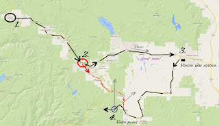
Highway 70 to Vinton (3) and then to Sattley turned out to be one of my most enjoyable motorcycle rides. It was a straight road with very little traffic and unlimited visibility--my favorite conditions.
Annotated
I took this picture outside of the gas station in Vinton (3).
A current Google Street View of the same place. It's now a church. What a difference 30 years makes.
Two pictures of a young Joe at the Vista Point (4). You can see the Sierra Valley which stretches out to Hwy 70 behind me in the first picture. I'm pointing toward Vinton in the second picture. Highway 49 hugs the Sierra foothills.
Looking back (Google Street View) toward the Vista Point and Sierra Valley beyond.
Homeward bound.


